
Tintagel (England, UK) around 700 AD
Author and source of the reconstruction: Aaron Watson
u/MateuszC1 — 2 days ago
Author and source of the reconstruction: Aaron Watson
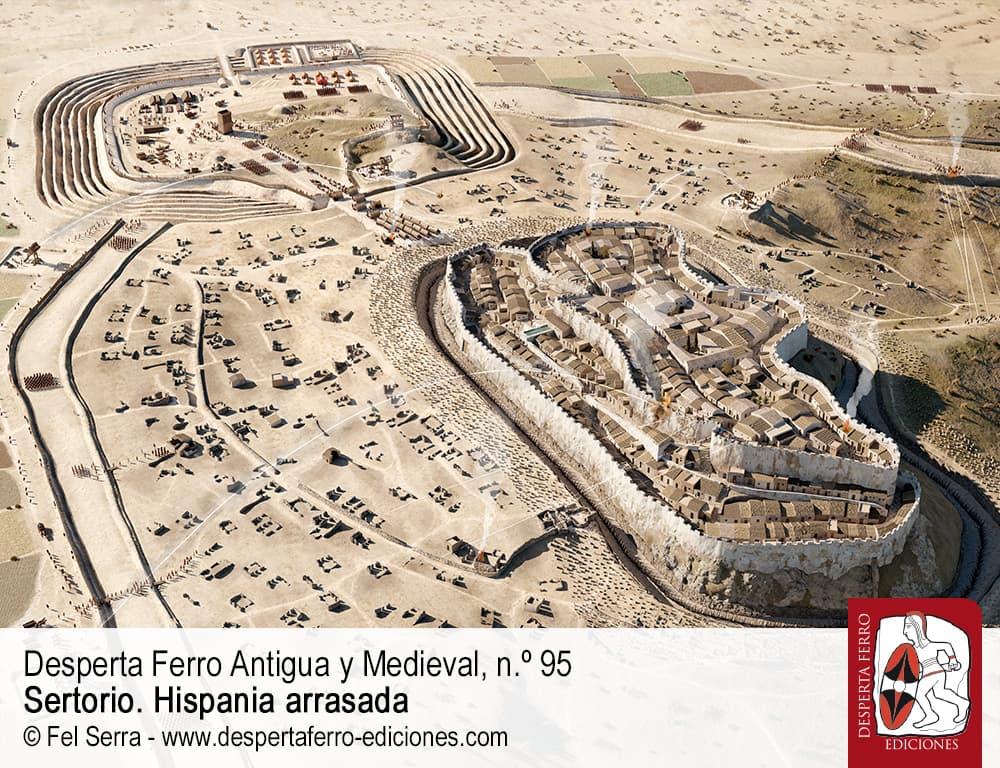
Cabezo de Alcalá is an archaeological site located near Azaila, in the region of Aragón, Spain. The ancient name of the city is unknown, although some researchers have suggested that it may have been Sedeisken.
This town was destroyed as a result of the Sertorian War, one of the Roman civil wars of the first century BC. Between 74 and 72 BC, the troops of Pompey laid siege to the town, which supported Sertorius.
In order to breach the fortified enclosure, they constructed a ramp using materials taken from the houses in the outer districts. The ramp enabled them to cross the moat and the walls, allowing them to enter the city and destroy everything in their path. The settlement was never rebuilt.
Author and source of the reconstruction: Fel Ferra
This map (Dorsten) is from Topographia Westphaliae by Matthäus Merian from 1647
Here's a zoomable hi res version and my source!
I've been into both maps and 3D printing for quite a while, so I've been making 3D city maps. It's a fun mashup of hobbies!
Very happy with how this Baltimore map turned out. The water front makes for a great feature for it.
Just to clarify, I don't just use an online tool to quick generate a map for me. I use Lidar data (which is basically laser scans of cities from an aircraft) which requires a ton of manual clean up work. It's worth it though as this gives me as much detail for the buildings as possible. Here is a quick comparison of the type of map that I make vs what most people do: https://imgur.com/a/STX96Li
I offer these finished maps as a bit of a side hustle at the moment, so if you want one you can take a look over at. I have a handful of cities at this point.
https://metromap3d.com
This map (Berna) is from M.Z. Topographia Helvetiæ by Matthäus Merian from 1654
Here's a zoomable hi res version and my source!
This map (Leodinium. Liege.) is from Topographia Westphaliae by Matthäus Merian from 1647
Here's a zoomable hi res version and my source!
Source: model is in Tower of David Museum and map from alamy.com
This map (Oldenburgh) is from Topographia Westphaliae by Matthäus Merian from 1647.
Fun history fact: The House of Oldenburg that originated and ruled in this city until 1918 currently sits on the thrones of Denmark, Norway, and the UK (from an agnatic pov)
Here's a zoomable hi res version and my source!
This map (Spa) is from Topographia Westphaliae by Matthäus Merian from 1647
Here's a zoomable hi res version and my source!